Showing posts with label Washington State. Show all posts

04 December 2010

Minerals, Mining, and Water III: Gold Mining and the Columbia River

Tiffany Mountain (1980 m)
Okanogan County, Washington
©eop

It has been awhile since last I commented on mining, but today I came across several articles in various newspapers and other sources discussing mineral extraction in relation to water resources. A gold mine in Okanogan County, Washington has been a topic of concern for people in the Pacific Northwest for several years. The Canadian mining company operating the mine was recently fined by the State of Washington for filing false reports on water testing. Now that company wants to explore nearby areas for further mining activities, potentially profitable given the recent spikes in the price of gold. Draining into the Columbia River, the streams leading from the highland mining areas could bring arsenic, mercury and other toxic materials into the river. Water from the Columbia is used downstream for drinking water, for irrigation, and for recreation. While quite a distance away, the lower reaches of the river are also important salmon breeding areas.There is a fear of a toxic spill polluting that river in much the same way as smelter tailings and emissions at Trail, BC, just upstream on the Columbia, have contaminated nearby areas and Lake Roosevelt behind Grand Coulee Dam. There is an ongoing large-scale study of the contamination of the river by that smelter just across the international boundary. The Province of British Columbia is also conducting ongoing studies of contamination of air, water, and soil by the emissions from the smelter.


Enhanced by Zemanta

01 November 2010

Dams III - Dam Removal

Aerial view of Elwha River Dam, Washington State

As they age, fill with silt, or water resource management priorities change, a large number of dams have been slated for removal. Most of those removed and proposed for removal have been smallish. The Elwha Dam, a decommissioned hydroelectric facility, inside the boundaries of Olympic National Park (the dam was built before the park was created) in the northwest corner of the continental United States is the largest dam to date to be put forth as a candidate for removal, and in September 2011 removal activity is scheduled to begin.

Removing a dam is very nearly as complicated as erecting one. Careful plans are necessary in order not to do great damage downstream. Fortunately the Elwha is a large river in flow but a short one, and the dam is only a few kilometers from its mouth into the Pacific at the Strait of Juan de Fuca. There is not much economic activity or infrastructure subject to damage downstream from the dam, making the removal problem a little less complex than it would be for most dams of comparable size.

Source: USGS

The blog "On Water" from the Water Resources Center Archive at the University of California, Berkeley (my graduate alma mater) is an extremely valuable resource for materials on water issues. Its primary focus is water in California and nearby western states, buts its coverage goes well outside the limits of that state and region. On 28 October it published a listing of links to sources on dam removal.

Related articles
Enhanced by Zemanta

12 August 2010

Slurban Water Supplies: The Case of Kitsap County, Washington I

Eagle Harbor,  Bainbridge Island (née Winslow)
Kitsap County, Washington, Winter 2004
©EOP

When thinking about the problem of inadequate water supply for urban and slurban areas in the U.S., one usually thinks about the sprawling cities of the desert, probably including Albuquerque, Las Vegas and Phoenix. Even without climate change, those cities are likely to "run dry," that is outgrow feasible sources of inexpensive water, should growth resume after the Cheney-Bush economic crash. Only draconian restrictions on water use or immensely expensive new water projects will allow growth to continue at anything approaching the rate of the 1990-2005 period. One is not inclined to think of Seattle with its somewhat undeserved reputation for heavy rainfall (undeserved because Seattle actually receives less rain in a typical year than a number of East Coast and Midwest cities - Seatac Airport (SEA) receives about 930 mm of rain per year, while Washington National Airport (DCA) gets 1011 mm and St. Louis Airport (STL) gets 956 mm). In fact, in common with other U.S. cities in humid regions, Seattle, and especially some of its slurban territory, also faces problems of future water supply. This is especially true for those areas dependent on ground water, on aquifers, for a large part of that water.

The Kitsap Peninsula, a ferry ride from downtown Seattle on western side of Puget Sound, is a rapidly slurbanizing part of the Seattle metropolitan area. Despite its many cloudy days, Kitsap County (more or less coterminous with the Kitsap Peninsula plus Bainbridge Island) is facing potential water shortages over the next two decades. It grew from about 84,000 people in 1960 to about 240,000 in the fifty year period 1960-2010, by Sunbelt standards a moderate rate of growth. During that growth the county shifted from a mostly rural area with a small industrial city (Bremerton) to a largely slurban area. First to slurbanize was Bainbridge Island, a 35 minute ferry ride to downtown Searttle. A bit later, the expansion of military facilities, in particular the submarine base at Bangor on Hoods Canal, Naval Base Kitsap, contributed to slurban development of the peninsular part of the county. Most recently lower prices for real estate in comparison to the eastern shore of Puget Sound, especially for parcels with shoreline access or views of water and mountains, attracted many to the county.

Seattle and other cities on the eastern shore of the Sound depend primarily on surface streams fed by melting Cascade snowpack for their water supplies. Even though there are high mountains with glaciers and heavy winter snows both east and west, the Kitsap Peninsula is separated by salt water from those mountains, and its water supply is mostly from ground water supplemented by a few surface streams. The costs of piping water to Kitsap County from the Olympics or the Cascades have been considered prohibitive in an area where cheap water is taken for granted.

Most of the Puget Sound Basin was glaciated in the last ice age, and the area was near the southern terminus of the great continental glaciers, the depositional zone for glacial detritus. In consequence, much of the surface is underlain by permeable sand and gravel forming an excellent aquifer.The West Coast of the coterminus U.S.  has a Mediterranean type climate with most precipitation falling in the months from October to April and a summer drought. Because there is ample winter precipitation in most years (unlike much of California where winter precipitation is uncertain), the Puget Sound aquifers store enough water to allow for summer growth of the lush evergreen forests which once blanketed the Peninsula. At moderate rates of usage, the aquifers also allow for agriculture with some supplemental irrigation and human settlements. Common to all aquifers, however, the rate of withdrawal can exceed the rate of recharge and cause the water level to drop.

Surrounded by salt water, some Puget Sound aquifers form lenses of fresh water floating atop denser salt water. When enough fresh water is withdrawn, salt water intrudes into those lenses. Beyond some critical level of withdrawal, the aquifer can be damaged or even destroyed for future use.The image below was drawn for the San Juan Islands, a little further north in Puget Sound, but the situation is almost identical on the Kitsap Peninsula (and as we shall see in a later posting, Bainbridge Island).


A not inconsiderable portion of the water supply of Kitsap County goes to service the large US Navy facilities in and near its largest place, Bremerton, and the submarine base at Keystone on Hoods Canal, the arm of Puget Sound that marks the county's western boundary. Together those facilities exert an industrial demand for process water, Bremerton is one of the U.S. Navy's more important shipyards, an export demand as ships heading out to sea are stocked with water, and a residential demand for military and civilian personnel working and living on the bases. Waste disposal, including unknown quantities of toxic chemicals,  from those facilities has contaminated some of the aquifer under the county.

The combination of contaminated aquifers, salt water intrusions, and the possibility of draining the aquifers by too much use define the limits of water use in Kitsap County, as they do everywhere that ground water is used as the major water source. In a future posting we shall examine the water use in the City of Bainbridge Island (coterminus with the island), the most densely developed slurb in the county.
Kitsap County (pink area Naval Bases), Bainbridge Island at the Center of the Map

05 August 2010

Petroleum, Pipelines and Water

Whittier Oil field, wells along property line of Central Oil company and Murphy Oil company. Looking east. Los Angeles County, California. 1905. Plate 13-A in U.S. Geological Survey. Bulletin 309. 1907.

My expectations of more oil flooding out of the breech in the Gulf seem to have been misplaced, and the ongoing process of sealing the well ("static kill" in the lingo of the trade) seems to be working. Moreover, we are told by the EPA that a large fraction of the oil that gushed from the breech has now dissipated. I hope the EPA statement is true, but I fear in the not too distant future oceanographers of various stripes will find it to have been an over rosy evaluation of what future environmental historians are likely to describe as one of the greatest ecological catastrophes since the beginning of the industrial revolution. Anyway, the effects of  the BP spill on fresh water were minimal, and its effects on food supply through the contamination of one of the most important source areas for seafood should be clearer before the food course begins in the Spring.

Petroleum is not out of the water supply picture, however, nor is it likely to be until the age of petroleum ends. A pipeline leak in Michigan has contaminated the Kalamazoo River, a stream flowing into Lake Michigan, the primary water source for Chicago, Milwaukee, and many smaller communities. The Enbridge Spill, named after the pipeline company operating the breeched pipe, has been estimated to have dumped more than 3,755,00 liters (1 million gallons) of crude oil  into the river, causing some nearby residents to be evacuated and restrictions to be placed on the use of the river for water supply and recreation. It is lucky that no nearby large town uses the river as its major source of water!

Enbridge Michigan Pipeline and Spill Location

The Enbridge spill has not, as far as we know, killed or even seriously injured anyone. In 1999 a rupture in a gasoline pipeline sent that flammable liquid downstream in Whatcom Creek in the city of Bellingham, Washington. Three youths were killed, two of them while playing with the matches that ignited an immense explosion. The third victim was a recent high school graduate celebrating the arrival of warm weather with a afternoon of fly fishing downstream from the Olympic Pipeline spill at Whatcom Falls Park, probably killed by the fumes before his body was incinerated by the fire. Whatcom Creek flows, partially underground, near the center of Bellingham enroute to Puget Sound. Gasoline entered the city's sewers, and there was a realistic fear that much of the picturesque center of Bellingham would explode in a huge fireball. A number of structures in Bellingham were damaged, and the pumping plant at a sewage treatment facility on Whatcom Creek was all but completely destroyed. Indeed the Bellingham area, often ranked as one of the most desirable places to live in the United States, has an unfortunate relationship to oil and oil pipelines. Earlier this year 7 workers were killed in an explosion at an oil refinery about 50 km away, and since the events of 1999 the city has been on edge each time a spill has been reported, including a large underground one in 2007. Facing one of the most beautiful but also one of the most heavily utilized portions of Puget Sound, the city is also acutely aware of the possibility of a maritime accident, including one in Canadian waters less than 100 km distant, though a May 2010 article in the major Vancouver, BC newspaper thinks tanker leakage is unlikely.

View of smoke from Whatcom Falls Gasoline Spill, 1999

The old axiom that oil and water do not mix has considerable resonance in any discussion of water supplies. Neither the Gulf nor the Bellingham spills directly impacted on the supply of fresh water, though the Bellingham spill and subsequent explosion and fire did destroy a sewage treatment facility. It seems only a matter of time until an oil pipeline passing across a stream breaks and renders the stream unfit for use in the water system of some large city or another. A break in a pipeline or other large spill involving the Ohio or the Mississippi could render water from those rivers unfit for consumption for hundreds of miles and would all but inevitably affect a large city.

[At home we are suffering a water supply problem! A leaking hot water tank and a malfunctioning shut off valve for that tank means the water to the house is shut off until the plumber can fix it later in the day. Hardly equivalent to even a tiny part of the suffering of that fifth or more of humanity who lack access to adequate water, but it does generate more sympathy for them.]

26 June 2010

Artesian Water

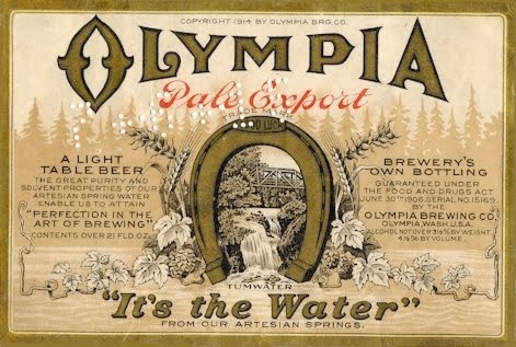
The beer was brewed until the 1980s in Tumwater, Washington (adjacent to Olympia) using artesian water, or so the brewery claimed. Today that beer brand is brewed in Southern California.

From the time I was a small child I remember people talking about artesian water, and until I was almost an adult I believed that it was somehow different from standard surface water or the water coming out of the tap. Advertising, including that for a popular brand of beer in the Puget Sound region, suggested that somehow artesian water tasted better or was more healthful. Based on marketing for Fiji water, a widely distributed brand of bottled water, that misconception persists.  In fact artesian is a description of the source and not of the water itself. Artesian water can be almost pure or nearly saturated with chemicals. Its primary trait is that it came from an underground aquifer where water is under pressure. When the aquifer comes to the surface a flowing or artesian well occurs. Many springs are of this sort.

A diagram of an artesian system where ground water is under pressure and rises to the surface when there is an opening. Source: http://www.littledippers.com/geocaching/ArtesianWell.jpg

Artesian wells are often a selling point for a property, especially a large property to be used for grazing where permanent surface water is distant or rare. In arid areas artesian seeps and wells are often the only source of water for many kilometers and thus are especially prized. In a later posting I plan to write a little about Australia's Great Artesian basin. The intense aridity of the outback would preclude almost all human use in many areas were it not for the water the artesian flow provides.

Artesian wells are but one aspect of ground water, a topic about which I shall have a great deal to say.

05 June 2010

Bottled Water: I A Personal History: When it seemed a good idea


Antique Soda Siphons, Antiques Street Market, San Telmo, Buenos Aires, Argentina 2008 © EOP


This is my week to be self-indulgent, so I thought I would take a few minutes to write about a subject that has become quite central to the discussion of water, bottled water. Peter Gleick's new book Bottled and Sold has generated a lot of buzz, as have various print and television advertisements - some of them promoting bottled water and others suggesting that it not be used. There is an online newsletter treating bottled water in somewhat the same fashion as wine, Bottled Water of the World. It would appear to have links to companies bottling water for sale and the publisher is FineWaters. The newsletter promotes the distinctive tastes of various waters bottled in countries around the world. On the other side various environmental groups have websites telling us it is best to drink tap water, for bottled water is horrifically expensive and environmentally destructive. Alternet Water is a good source of postings on the environmental problems of bottled water.

Growing up in the Pacific Northwest I was but vaguely aware of the existence of bottled water, encountering it only on vacation trips to Southern California. I was an adult travelling overseas when I first encountered widespread use of drinking water in bottles. The glass of tap water taken for granted in the US and Canada was not on offer in the restaurants of Continental Europe. One accompanied a meal with a purchased bottle, in my case usually con gas. When travelling in the poorer countries of Latin America and Asia bottled water was a necessity if one wanted to avoid cholera or similar water borne illness. In the mid-1970s  a cholera epidemic in Leningrad led to a US State Department recommendation to drink only bottled water, and I became accustomed to the rather foul taste of mineral water available in Soviet restaurants and hotels on a sojourn to attend a meeting in Moscow and Leningrad. Elsewhere bottled water generally tasted good, and drinking it seemed a small price to pay for avoiding disease.

For a number of years I thought little more of the issue and mostly drank tap water in the US and bottled water overseas, though I did become rather fond of carbonated water (I have never much liked soda pop) and bought it as a periodic treat, especially after prestige brands like Perrier became widely available. One summer we rented a farmhouse in the Cevennes not far from the Source Perrier, so we made a day trip, crossing the Canal du Rhône à Sèt adjacent to the Perrier bottling plant where we took a tour. The tour itself was a little strange, for it had a great deal to say about the manufacture of the bottles and the bottling process but said nothing whatsoever about Source Perrier, the fountain from which the special water is presumably drawn.

A few years later a brief period of residence in the Los Angeles area where the tap water is somewhat saline, or so it tasted to us, led us to join many Angelenos in mostly drinking bottled water and also using it for cooking. Then we moved back to the Pacific Northwest where tap water tasted good. Once again except on overseas trips we rarely drank bottled water with "fizzy water" as only an occasional treat. Abroad we were often thankful for bottled water in areas where the sanitary standards were questionable. An image remaining in my mind's eye is of porters carrying many bottles of water (and beer) on a trekking holiday in northern Thailand (that presents a bit of an ethical problem, but it was a long time ago).

The first awareness that bottled water was something more than an occasional luxury and a necessity in areas where tap water is unsafe or has an unpleasant taste came watching the film The Player where a comic theme is the lead character's obsession with bottled water. Shortly thereafter I became aware of people running and speed walking with bottles of water in hand and, using a word that irritates me like fingernails on a blackboard talking about "hydrating" themselves. Restaurants began to offer bottled waters, and all seemed well with the world. On a trip to Washington, DC before returning to live here again, we even noticed that some water fountains in the city had been turned off because tap water was declared unsafe, the problem was lead contamination ongoing to the present. Given that water in Fairfax County where we were condemned to live  tastes foul, I foresaw years of drinking bottled water. And bottled water was everywhere with whole sections of Costco and entire aisles of fancier grocery stores devoted to its sale.

What I failed to recognize was the long list of problems accompanying widespread consumption of bottled water. Fairfax water continues to be foul tasting, but we have deigned to drink it and use it in cooking. Why we have in a subsequent posting.

01 June 2010

Columbia Basin Project I

Grand Coulée Dam, 2005, © EOP


The Tennessee Valley Authority (TVA) is perhaps the most famous water project in the United States, but during the Depression years and the New Deal of the 1930s, several huge water projects were initiated or expanded under the control of the Bureau of Reclamation. As today is my birthday, I thought I might indulge myself and write a little about the one I know the best and with which my family has had close connections, the Columbia Basin Project an irrigation and hydroelectric scheme using the huge flow of the Columbia River, an exotic river flowing across the northern and central parts of Washington State. Its centerpiece is Grand Coulée Dam (shown above and again at the end of this posting) for many years the largest hydroelectric facility on earth and still the largest in the United States.

In the rain shadow of the Cascade Mountains, the Great Columbia Plain (pace Donald Meinig) was a vast steppe or high desert atop one of the more geologically interesting bits of the United States, the Columbia basalt flow. In the early years of settlement, after the Northern Pacific Crossed that steppe at a diagonal with its route from Spokane to Pasco, there was some settlement and dryland agriculture, wheat farming and ranching, but the area was lightly populated. Only water was necessary for an agricultural bonanza, it was claimed. The Columbia Basin Project, long a goal of Chambers of Commerce and other civic booster groups in the central and eastern part of Washington State, was intended to provide that water in a scheme similar, though not identical, to the TVA, with the dual goals of long term regional development and stimulus spending in a depression.

A make-work project to employ some of the large number of unemployed, Grand Coulée Dam was begun in 1933 and completed 9 years later, one of the largest engineering projects ever undertaken up to that time, though in publicity it was somewhat overshadowed by construction of Boulder Dam in a dramatic canyon of the Colorado River ongoing at the same time. When it was being built there was no clear idea of how or where the vast amount of electricity Grand Coulée Dam could produce would be consumed, though sale of electricity was to help fund the project and pay for the more than 1000 km of irrigation canals and drainage ditches the project would require if carried to completion. World War II defense industries, including Boeing's Seattle plants, rendered the issue of where to sell the electricity moot until 1945, after which a series of aluminum smelters purchased much of the electricity produced.

Meanwhile the irrigation scheme was constructed, albeit at a slower pace. Several of the major canals and drainage works were not completed until the 1960s and 1970s. Irrigation has transformed the sere steppe into an immense green expanse, at least in Spring and early summer. Areas where the distance between trees was measured in kilometers in the 1930s or even as late as the 1960s, have become orchards and vinyards. Dryland wheat or barley has been replaced by water intensive field crops including corn (maize). Sounds wonderful, the bonanza promised by early boosters, but the change has come at some environmental costs to be examined in a later posting.

Grand Coulée Dam, 2005, © EOP