Showing posts with label Fairfax. Show all posts

06 October 2010

Notes VII

Mendoza, Argentina  ©eop

In our first session we talked about siltation and the failure of dams. Over the past week, a small dam in the Kingstowne section of Fairfax County failed draining small lake and leading to the death of wildlife. Fortunately no human lives or even housing units were damaged by the dam failure, but it left a mess that will require a substantial sum of money to repair. That break was not unexpected, for the dam was in need of rebuilding, and the lake behind it had been fouled by silt. Left behind is a swamp, probably a stinking swamp should warmer weather return in the next week or two. Dams, like all human devices for water control, need constant maintenance if they are to continue in service. Failure to maintain can lead to catastrophic collapse, and a dam failure can lead to loss of property and even loss of human life.

The last half of the session today, 6 October, and a substantial part of the next session on 13 October depend on a Power Point presentation developed by Prof. Arjen Hoekstra at the University of Twente in the Netherlands. To review the materials used today and to preview those to be discussed in the next session, the Power Point or a PDF version of it can be downloaded from the page: http://www.waterfootprint.org/?page=files/Presentations 

13 August 2010

Notes VI

Heat Wave in the Indus Valley, June 2007

When I began preparing materials for use with the course on World Water Resources in the autumn, I copied a NASA space photograph of the Indus Valley (not the one above), encompassing Pakistan and large portions of its neighbors India and Afghanistan. Of necessity, India and especially Pakistan will be central topics in the course, but I did not anticipate the catastrophic flooding that has accompanied the summer monsoonal rains of 2010. Control of the waters of the Indus is one of the longest activities of civilization, for the residents of  Mohenjo-Daro and Harrapa, civilizations which flourished almost 5,000 years ago, used the Indus to irrigate their fields and feared its droughts and floods. The current flooding is but one season in an almost constant effort of people to make a livelihood from a beautiful but punishing environment.

Sumer Flooding in the Indus Valley, 3 August 2010


Meanwhile, rains have cooled Moscow somewhat, but peat fires remain a problem. This morning's New York Times has a good piece on peat fires. Along with an explanation of why those fires are so smoky, it also examines how a decision some years ago to drain bogs and mine the peat to use as fuel in electrical generating plants is partially to blame for the smoky fires, dangerous to health, of the extraordinarily hot summer of 2010.

Near the Potomac River, in Loudon County, VA a few kilometers northwest of the Fairfax County boundary, the real estate speculator Donald Trump is redeveloping a golf course. Today's Washington Post reported on the massive tree clearance on that roughly 325 hectare site. The spokesperson for Trump was quoted as saying "The trees threatened the shoreline. Many of the trees, ... stress and eroding (sic) the soil." I guess those trees are like the forest trees claimed by other public relations flacks to create air pollution and acid rain. Loudon County, and its neighbor Fairfax County should encourage widespread cutting of trees, deforestation, in order to protect the environment!

11 August 2010

Trees, Dirt and Streams

Raw Dirt, Construction Site, George Mason University
Fairfax, VA, August 2010
©EOP

Yesterday afternoon, with the car thermometer registering 101 degrees F, I drove to the Vienna-Fairfax Metro station to pick up my wife. The area just south of the station looked radically different from its visage on my last trip to that station a few weeks earlier. A wooded area of several hectares had been stripped of all vegetation and was bare dirt being worked over by large construction machinery. It is the second property near the intersection of Route 29 and Nutley Street recently stripped of vegetation for new construction. In close proximity to the Metro Station, high density land uses are certainly justified, but was it necessary to clear away every last tree?

Fairfax County claims to be concerned about its tree cover, and has an ordinance to that end which, according to a news release from the County:

The Fairfax County Board of Supervisors adopted a tree preservation ordinance at its Oct. 15 (2007) meeting, protecting four types of trees. Under the new law, individual specimen, heritage, memorial or street trees can be protected from being cut down.
The new measure is not intended to protect large wooded tracts. Instead, the law only affects individual trees that property owners voluntarily agree to safeguard.
The board approved the law because even a single tree can benefit the environment. One mature tree with a 26-foot canopy can absorb the emissions of a vehicle driven 11,500 miles every year.
Homeowners, residents or groups can recommend individual trees for protection. After a public hearing, the board will approve the preservation of specific trees. Easements also may be required to protect a tree’s roots. If needed, property owners will donate the easements to the county.
As defined by the law, specimen trees are those that are notable in their size and quality for their species. Heritage trees have a historical or cultural interest. Memorial trees, as the name suggests, commemorate a memorial. Street trees are those that have been planted by the county on public rights of way.
There is a $2,500 fine for removing a protected tree without permission from the county. The ordinance takes effect immediately, and it has been added to the county code as chapter 120.
The preservation ordinance supports the county’s 30-Year Tree Canopy Goal adopted by the board in July. The county aims to blanket 45 percent of the county with tree cover by 2037. It is important to preserve existing trees because the county expects to lose 4 percent of its canopy during the next 30 years. To reach the goal, the county and the public also will have to plant an additional 2.6 million new trees.
Once achieved, the canopy goal is expected to save taxpayers money. The trees when matured should produce savings equivalent to $5.3 million for air pollution removal and $4.7 million in energy conservation every year. The additional canopy also will have the capacity to absorb more than 10 million pounds of carbon dioxide annually, which could eliminate the need for $1 million in greenhouse gas reduction services each year.
For more information about the new ordinance or 30-Year Tree Canopy Goal, call 703-324-1770, TTY 711, or visit www.fairfaxcounty.gov/dpwes/environmental/trees.htm.

It is interesting to note that the ordinance applies only to specific trees, not to forested areas. Since much of the woodland in the county is second growth, frequently a product of the reforestation of exhausted tobacco and other farm lands since the early and middle parts of the 20th century, that forest growing on nutrient poor land contains very few "specimen" trees notable for their age, girth, historical importance or beauty. Moreover, the ordinance only applies if land owners agree.

Fairfax City (under Virginia's peculiar local government system not a part of Fairfax County even though it is completely surrounded by it) calls itself a "Tree City USA." The City does indeed have many grand old trees and small woodlands, one of the strongest reasons attracting us to live here. Fairfax City has a stringent ordinance requiring City permission for tree removal. Despite that ordinance, a large parcel on the eastern edge of the City adjacent to Main Street (Route 236) was stripped of all vegetation for construction of residences just as the Cheney-Bush recession began in 2008, and the land has remained bare dirt since. As of a few weeks ago activity at the site has suggested that building will commence soon, but for about two years, through the melting snow of intense winter blizzards and torrential summer rainfall, dirt has eroded from that parcel into storm sewers flowing into nearby streams.

There has been a construction boom on the Fairfax campus of George Mason University over the past several years, and while some of that building used sites that previously had been parking lots, a major project at the north west corner of the campus, adjacent to Fairfax City, has also stripped several hectares of all vegetation. At the height of land, the site is the headwaters for a small stream which flows across the campus into a  holding pond. Despite some serious efforts to minimize erosion during construction, recent heavy rain has turned that pond a muddy brown, filling it with silt from the construction site a few hundred meters to its north. Eventually some of that silt will wash into the Occoquan, a primary source of water for the Virginia slurbs of Washington, DC.

Mason Pond, muddy after summer thunderstorms
George Mason University Campus, Fairfax
©EOP

Discussion of deforestation frequently focuses on the widespread cutting of trees in the Amazon Basin, in Brasil's Atlantic rain-forest, in Borneo or elsewhere in the tropics. In fact deforestation is a matter of consequence in many other areas. A recent Scientific American posting suggested that urban dwellers are driving deforestation. It was focusing on conditions in poorer countries where urban demand for food and fuel is leading to forest clearance, but the argument could well be extended to the United States where the demand for new slurban construction sites is causing large areas to be stripped of trees and other vegetation.

Fairfax City and County together have a large set of small-scale clearances which, in total, have a substantial impact on climate and water flow.The cooling effect of wooded land on nearby areas is well-known and easily demonstrated. On a hot and sunny summer day, walk from a copse of trees, even a small one, onto a patch of bare ground and the difference is instantly apparent. In a heat wave like the ones that have blighted the summer of 2010, a wooded area can be as much as 5 degrees C cooler than nearby open areas.

The effects of wooded land on water flow are a little more complicated. Forests even out the flow of streams, holding back some of it during and just after heavy rain and then releasing water in drier periods. The geology and soil of the Fairfax area and the torrential rains common with summer thunderstorms provide perfect conditions for filling streams with silt when the soil is bare.Wooded areas slow and filter the rapidly flowing rainwater draining after a storm, and they retain much of the material that could become silt. Water authorities in the county and nearby are well aware of the problems deforestation, and impermeable surfaces like paving  (a subject for another posting), create. Heavy rains in deforested areas lead to rapid runoff of silt loaded water into streams and reservoirs, while in a longish drought like the one in the first part of summer 2010, those streams and impoundments diminish or even dry up (their storage capacity getting smaller each storm as silt accumulates). When needed for water supply, that shrinkage can lead to sleepless nights for water managers after a long dry spell!

02 August 2010

Bottled Water II: The Baltimore-Washington Area

Infrared photographs of zone between Baltimore and Washington, DC 1973 and 2002 showing increase in urban development. Source: NASA Earth Observatory

Awhile ago I posted some comments on bottled water. When thinking about bottled water, we mostly think of the small bottles people who jog, bicycle, or want to appear addicted to exercise carry with them along with the multi-liter bottles on the refrigerator shelf. According to a television advertisement for Britta philtres, people in the United States annually empty enough of those bottles to encircle the earth 100 times. The costs in monetary terms and in environmental damage from consumption of that kind of bottled water are substantial, a topic we may examine in a little more detail at some later date.

Another kind of bottled water is known to people in urban areas where large (and mostly reusable) jugs of water are delivered to office and shop water coolers. That business, like the sale of smaller bottles, is huge as evidenced by a fawning piece in the pathetic business section of todays right-wing Washington Post (WP). The Washington-Baltimore metropolitan area is supplied by an oligopoly composed of two multi-national firms Crystal Springs and the Nestle owned Deer Park along with a much smaller local firm DrinkMore Water (also peddling small bottles with custom labels through its division called DrinkMore Custom Water). Those firms will deliver to private residences, but the bulk of their sales are to large customers in offices, retail establishments, and factories. The evidence in the piece published today by the WP is the market is growing.

The reasoning for having water delivered rather than using tap water for employee and customer drinking is complicated, but a simple analysis would suggest that it is almost never justified. By any measure, bottled water, even that in large jugs, is far costlier than water from the tap. Instead of fractions of a penny per liter, the bottled water costs 10 cents or more per liter, often substantially more. The cost is quite variable depending on how much water is delivered to a given location. For home delivered water at $7.50 per 19 liter container (5 gallons) advertised by DrinkMore Water in the DC area, the bottled water  is about 40 cents per liter. Fairfax Water tap water costs its residential customers between $1.94 and $2.08 for 3,785 liters (1,000 gallons) or about 0.55 cents per liter at the county water agency's highest rate.

The water delivered by the oligopolistic companies is generally safe water, at or below maximum acceptable levels of bacteria and other contaminants, but the water delivered by urban water supply systems through the taps also meets that requirement. The Environmental Protection Agency (EPA) has established maximum allowable levels for various contaminants, and it requires frequent testing of water by suppliers to ensure water is not contaminated beyond those levels. Advertising to the contrary, it is not at all clear that bottled water is any healthier or safer to drink than tap water, except in a very few special circumstances when local tap water is contaminated. In the end, taste is the primary selling point, and the companies argue their water has a better taste because of special filtration.

Recent postings have noted water supply issues in the Maryland area served by Washington Suburban Sanitary Commission. At the moment there are no restrictions or advisories, but ones in the recent past have been alarming. In the District of Columbia, lead in the water remains an issue and will until a vast investment is made in replacement of aging pipes, though the use of orthophosphate and other treatment has reduced the levels of lead in almost all of the water to the EPA maximum or less. The District of Columbia Water and Sewer Authority offers lead testing for concerned customers with lead problems frequently occurring within private structures and not in the public water mains. The water in Fairfax County, Virginia the largest suburban jurisdiction, tastes foul to many of us, but it meets or exceeds EPA standards, and the foul taste can be removed using simple filters like those sold by Britta. Despite those reservations, all of the evidence suggests that there is really little reason for the vast majority of commercial sites in the Washington-Baltimore metropolitan area to depend on delivered bottled water. In addition to the monetary costs noted above, each of those oligopolistic companies selling bottled water has a fleet of trucks driving many kilometers each day in order to serve customers scattered over several thousand square kilometers of territory and contributes to environmental contamination in several other ways as well.
Enhanced by Zemanta

15 July 2010

The Occoquan Watershed

George Mason University Campus Fountain, July 2010
©EOP

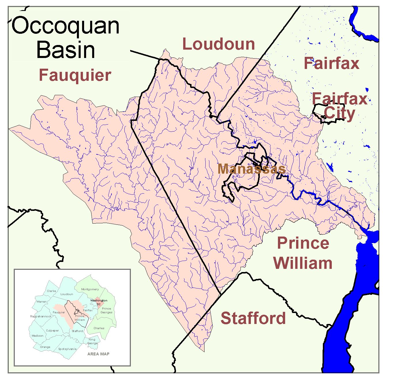
This morning I was looking for some local materials to include in the water course, and I chanced upon a good (if too small a scale) land-use map for the Occoquan Watershed (I hope to find a similar map at a bigger scale for use in a Power Point). Our Fairfax City house sits just slightly to the Potomac watershed (small streams draining directly into the river) side of the interfluve dividing the watersheds of the Potomac and the Occoquan. The GMU campus sits on the interfluve,and a part of the campus is on the opposite slope with water draining into small streams feeding the Occoquan (which itself eventually, just southeast of its eponymous town, flows into the Potomac).

Bull Run, one of the Occoquan's tributaries is very famous, for its small valley at the edge of Manassas City was the site of two of the more vicious battles of the Civil War. At the time of the Civil War and until quite recently the almost 1550 square kilometer basin of the Occoquan was predominantly rural with farmlands, wooded areas and only a few small towns and the small city of Manassas. Since the 1970s and especially since 1990 the watershed has  been rapidly urbanized with farm fields and pastures converted to townhouse projects and small "estates" along with the usual fast food and strip mall development. That has radically changed the timing and the quality of water run off into the Occoquan, for now much of the watershed is paved and impermeable even as urban uses add contaminants to the water flowing toward the river..

Prior to much urbanization the river became an important drinking water source supplying much of the urban water in Prince William County (including Manassas and Manassas Park cities) and some of the water consumed in Fairfax County, the two largest counties by population in Virginia. Altogether nearly 1,200,000 people are connected to water supply systems which use some Occoquan river water. A substantial dam impounds a tributary of the river and creates Lake Manassas, a water supply reservoir for its namesake city. Downstream another dam impounds the Occoquan Reservoir supplying much of Prince William County and large parts of adjacent Fairfax County. While other sources of water are used by both counties, the Occoquan could in an emergency supply most users. A bit further downstream yet near the town of Occoquan is one of the largest sewage treatment facilities in the Washington, DC metropolitan area, sending treated water into the Occoquan just before that river joins the Potomac.

A crucial element in the urban water supply of Washington, DC's Virginia slurbs, the Occoquan is also a major recreation resource for the area, and the undeveloped lands along its banks provide a substantial amount of open space. Unfortunately the stream is badly polluted in places, and runoff from developed areas makes it an endangered stream. The Prince William Conservation Alliance has an excellent webpage examining the issues of pollution in the Occoquan basin. The quality of water in the river is important for those of us condemned to live in Northern Virginia!

13 July 2010

Notes

Windmill, Pacific Ocean near Todos Santos, BCS, Mexico 2009
©EOP

Occasionally I shall post some random notes about issues, comments that do not fit together coherently. This is the first such posting.

This morning I was looking for some materials on local water concerns to use with the course, and I learned of a problem which was new to me. Fairfax City includes within its boundaries a sizable tank farm, a gasoline and diesel fuel depot. In 1992 there was a large underground spill that sent gasoline and other petroleum derivatives in a plume far downstream into the Mantua area of Fairfax County. That leakage cost a huge amount of money spent to clean up impacts in a scenic and generally uparket residential area. I had not paid attention to a much smaller leakage found in late 2009 which has not yet been fully cleaned up. The leak is fairly small, but it marks yet another insult to the land and waters of the Potomac Basin.

Several weeks ago I read reviews of James Lawrence Powell's Dead Pool (Berkeley: University of California Press, 2008, ISBN 978-0-520-25477-0), a  history and analysis of the dams on the lower Colorado especially Glen Canyon and Boulder Dams. The reviews were correct, for it is one of the most important books on water issues in the United States published in the past decade and should be required reading for almost everyone concerned with water supply in an era of population growth and climate change. The first few pages describing what might have happened if Glen Canyon Dam had failed in 1983 make for harrowing reading. The remainder of the book examines how the dams have shaped life in the southwestern corner of the continental US (and in adjacent parts of México) and what may happen as rainfall decreases due to climate change, reading almost as harrowing as the first few pages.