25 January 2011

New Year Water Issues

Flooding in Brisbane, Australia suburbs January 2011

It has been awhile since I last posted. The holidays, a family member's illness, and generalized winter lethargy are to blame for the lack of comments and linkages. Water issues, on the other hand, do not take seasonal holidays, so some largely unrelated issues need at the least to be enumerated.

Once again the Washington Suburban Sanitary Commission has had a trunk line water main break with a string of associated problems. Yesterday, on the coldest morning of the current season, much of the Beltway (I-95) in Prince Georges County, MD was closed for several hours due to flooding, and some serious damage was done to nearby surface streets, at least one commercial structure, and several automobiles. The U.S. Census Bureau's headquarters were shuttered for the day due to lack of water, and a number of local businesses had to close as well. Today residents of Prince Georges County served by that trunk water main have been instructed to continue boiling water before use.

Too much water has also been a problem in Australia, especially in Queensland. After years of drought and draconian restrictions on water use in some parts of Australia, the current summer with the strongest la niña in a generation or more has seen huge quantities of rain in some of that continent's normally arid and semi arid areas. Thousands of housing units have been damaged or destroyed, roads and other transportation facilities have been closed and damaged, and flooding in agricultural areas may contribute to a large uptick in world food prices in the next few months.

The role of global climate change in the Australian floods is a matter of debate. Less so is a report just issued suggesting that the Czech Republic may be the first state in the European Union to suffer from water supply problems due to warming air and redistribution of precipitation.

20 December 2010

Drinking Water

Millrace, Mt. Vernon Distillery and Grist Mill Park, Fairfax, VA
©eop
For residents of the Washington, DC area, there have been a number of drinking water issues in this current, exceptionally cold, early (meteorological) winter. Water main breaks have been all too common, especially in the District of Columbia and in portions of Maryland served by the Washington Suburban Sanitary Commission. A combination of long periods of freezing weather and old pipes makes long established urban areas vulnerable to breaks. While the District of Columbia claims to be replacing old pipe at an accelerated rate, there are still many kilometers of old cast-iron pipe, so weather induced breaks are to be expected until warmer weather returns.

A second issue raised in Sunday's right-wing Washington Post is the presence of hexavalent chromium in the water supplies of a number of urban areas including Washington. While I have not seen the movie (I do not care for Julia Roberts in any role), apparently that chemical was the cause of the supposedly courageous activities of Erin Brokovich. Hexavalent chromium is a known carcinogen, but at the moment its presence in drinking water is noted but not regulated. Current evidence indicates the chemical is in the water supplies of many urban area in the United States.
Enhanced by Zemanta

04 December 2010

Minerals, Mining, and Water III: Gold Mining and the Columbia River

Tiffany Mountain (1980 m)
Okanogan County, Washington
©eop

It has been awhile since last I commented on mining, but today I came across several articles in various newspapers and other sources discussing mineral extraction in relation to water resources. A gold mine in Okanogan County, Washington has been a topic of concern for people in the Pacific Northwest for several years. The Canadian mining company operating the mine was recently fined by the State of Washington for filing false reports on water testing. Now that company wants to explore nearby areas for further mining activities, potentially profitable given the recent spikes in the price of gold. Draining into the Columbia River, the streams leading from the highland mining areas could bring arsenic, mercury and other toxic materials into the river. Water from the Columbia is used downstream for drinking water, for irrigation, and for recreation. While quite a distance away, the lower reaches of the river are also important salmon breeding areas.There is a fear of a toxic spill polluting that river in much the same way as smelter tailings and emissions at Trail, BC, just upstream on the Columbia, have contaminated nearby areas and Lake Roosevelt behind Grand Coulee Dam. There is an ongoing large-scale study of the contamination of the river by that smelter just across the international boundary. The Province of British Columbia is also conducting ongoing studies of contamination of air, water, and soil by the emissions from the smelter.


Enhanced by Zemanta

03 December 2010

Lead in Washington, DC's Drinking Water

Capitol from Hirshhorn Museum Sculpture Court, Washington, DC
©eop

In common with the situation in most other major cities in the eastern United States, lead in the local water supply has been a concern in Washington, DC for the past half century. Lead pipes and lead welds on water supply pipes made of other materials created a potential hazard for those consuming the water, especially for growing children. Over the past two decades there was a massive effort to reduce lead in the water supply. Now it is reported that effort was inadequate to reduce lead levels in about 15,000 residences. The deleterious effects of lead on the bodies and brains of those who are exposed to it in drinking water are numerous and profound, and there is a great concern about what this discovery may mean for those children living in the residences where lead levels remain high. An article in press expresses both the problems and the levels of hazard in Washington, DC (Brown, M.J., et al., Association between children’s blood lead levels, lead service lines, and water disinfection, Washington, DC, 1998–2006. Environ. Res. (2010), doi:10.1016/j.envres.2010.10.003).

Enhanced by Zemanta

21 November 2010

Food Supply Notes

End of Sumer Corn, Fairfax City Farmers Market 2010
©eop
While the course on World Food Supply: A Famine in Our Future will not be offered at OLLI, I have continued to collect materials and read about the subject. The other day the Guardian from the UK had a disturbing article Food Prices May Rise Up to 20%, Warns UN. A combination of factors, most of them related to climate, have resulted in poor grain harvests in various places. We have already noted here the effects of drought on Russian grain production, long-term drought in Africa and the devastation of agricultural land in Pakistan as a consequence of flooding. Crops in parts of North America were good, but increased demand for maize (corn) and other food crops for bio-fuels adds a great deal of uncertainty to price predictions. Added together, those factors lead to a decline in the world's supply of basic food and feed grains and promise to drive prices up. The increase in food prices in Africa and some of the poorer parts of Asia are all but certain to lead to increased hunger, though for the moment starvation and famine would appear to be over the horizon. It is quite worrisome, and it will be more so should the 2011 growing season in the Southern Hemisphere, including the grain producing areas of South America and Australia, produce poor yields.

On a loosley related issue, I am a great fan of bargain bins and used book sales. The other day I was at a local branch of one of the huge bookstore chains and happened on remaindered copy of a volume which I find fascinating, an encyclopedia of the world's food plants Edible: An Illustrated Guide to the World's Food Plants (Washington, DC: National Geographic. ISBN 978-1-4262-0372-5 for the North American edition of a book that was originally published in Australia). With the National Geographic's (should really be called the National Photographic!) signature color photography, the book is an excellent guide to the what, where, and why of world food plants and great fun to thumb through or to use as a reference to look up some unusual food plant or another.
Enhanced by Zemanta

20 November 2010

Pakistan Flooding

Pakistan late Summer 2010
For a variety of reasons I have been a little obsessed with the floods of the 2010 summer monsoon season in Pakistan. My original idea had been to use Pakistan, a country very much in the news, as a central case study in the water resources course with the idea that the country is chronically short of water and subject to political pressures internally and from India related to water supply and use. Then a few months before the course began Pakistan was hit with excess rainfall and flooding of catastrophic levels. I decided it was wisest to severeky curtail the use of Pakistan as a case. Should I teach the course again, I will have the prospective of time to examine the issue of 2010's flooding, its potential links to global climate change, and the meaning of it to a country usually suffering from drought, or worried about a lack of water. Meanwhile, NASA's Earth Observatory has posted a fine view of the flooded area from space and a brief, but as almost always concise and informative description of that photo in "Flooding in Pakistan," well worth a look!

06 November 2010

Treaties and Compacts

Boundary Waters of Canada and the United States

On Wednesday the question was raised "What is the difference between a treaty and a compact?" I did not have a good answer at the time, and having devoted some research effort to the issue since, I still have not found a difference of consequence for most purposes, though there appears to be one of usage in the United States. In the dictionaries I have consulted, including paper ones on my shelves and online ones, there is virtually no difference in definition of the two terms, both being defined as agreements between individuals or states to resolve conflicts.

In the US the word "Compact" seems to be mostly used for agreements between states as in the "Great Lakes--St. Lawrence River Basin Water Resources Compact is a legally binding interstate compact among the U.S. states of Illinois, Indiana, Michigan, Minnesota, New York, Ohio, Pennsylvania and Wisconsin. The compact details how the states manage the use of the Great Lakes Basin's water supply and builds on the 1985 Great Lakes Charter and its 2001 Annex. The compact is the means by which the states implement the governors' commitments under the Great Lakes-St. Lawrence River Basin Sustainable Water Resources Agreement that also includes the Premiers of Ontario and Quebec." (quoted from Wikipedia entry). Of course there is an international component as two Canadian Provinces are also involved, though neither the US Federal Government nor the Government of Canada appear to be direct parties to the Compact.

Treaty, on the other hand, seems to be used in the US to mean an agreement between the Federal Government and a foreign country (or countries). One example is the longstanding Boundary Waters Treaty between the United States and Great Britain (acting for Canada) signed in 1909 and ratified the next year. Creating an International Joint Commission of the two national states, the treaty is an agreement to provide mechanisms for resolution of disputes over the rather numerous water issues that arise between them. A great number of streams cross the boundary, including two huge ones in the West, the Columbia and the Yukon. The Great Lakes - St. Lawrence River Basin is a large share of the boundary waters and the most important watershed for the economies of the Canada and the United States, and it is part of the zone covered by the treaty. The Compact noted above is apparently a response to the Treaty at the level of states and provinces which have great responsibilities for water issues in their respective countries.

This is a none too satisfactory response to the question raised, and the difference between treaties and compacts is one I shall devote some additional effort to leaning about once I have completed a series of projects which are more pressing at the moment.

01 November 2010

Dams III - Dam Removal

Aerial view of Elwha River Dam, Washington State

As they age, fill with silt, or water resource management priorities change, a large number of dams have been slated for removal. Most of those removed and proposed for removal have been smallish. The Elwha Dam, a decommissioned hydroelectric facility, inside the boundaries of Olympic National Park (the dam was built before the park was created) in the northwest corner of the continental United States is the largest dam to date to be put forth as a candidate for removal, and in September 2011 removal activity is scheduled to begin.

Removing a dam is very nearly as complicated as erecting one. Careful plans are necessary in order not to do great damage downstream. Fortunately the Elwha is a large river in flow but a short one, and the dam is only a few kilometers from its mouth into the Pacific at the Strait of Juan de Fuca. There is not much economic activity or infrastructure subject to damage downstream from the dam, making the removal problem a little less complex than it would be for most dams of comparable size.

Source: USGS

The blog "On Water" from the Water Resources Center Archive at the University of California, Berkeley (my graduate alma mater) is an extremely valuable resource for materials on water issues. Its primary focus is water in California and nearby western states, buts its coverage goes well outside the limits of that state and region. On 28 October it published a listing of links to sources on dam removal.

Related articles
Enhanced by Zemanta

Dams II - Belo Monte Dam in Brasil

Belo Monte Dam Proposal


Last session I mentioned recently learning of a huge dam, slated to be the third largest on earth, cleared to begin construction, but I could not remember which river or what country. It is the Belo Monte Dam on the Xingu River in the State of Pará in Brasil. It is almost exclusively a hydroelectric project and will attempt to capture some of the energy of the Xingu, one of the world's longer and larger rivers by rate of flow and the final huge tributary of the Amazon before it enters the Atlantic. As I noted "dictators love dams," and the original proposal for the Belo Monte Dam dates to the military dictatorship that misgoverned Brasil a generation ago. Like many bad ideas, however, the proposal did not die when the dictatorship ended.

One of over a hundred proposed hydroelectric dams in the Amazon basin of Brasil, when and if constructed, the Belo Monte Dam will flood a vast area of biologically diverse tropical rain forest and displace a large number of first nations people. Its proposed construction has generated a huge controversy. Various organizations within Brasil (a source from Brasil in English) and outside like the non-profit International Rivers have protested the construction and are likely to continue doing so even though the dam project appears to have cleared the final legal hurdle. It will be a vastly expensive project, and one of the expenses is a requirement that the winning bidders pay the equivalent of almost a billion US dollars to create national parks, ecological reserves, and homes for the 20-40,000 people who will be displaced by flooding when the reservoir is filled. The director James Cameron and members cast of the cartoon Avatar have been among the most vocal opponents of the dam outside Brasil, and they have produced a film narrated by the actress Sigourney Weaver to raise awareness of their protest.

A few days ago Brasil elected a new president, its first female head of government. It is unlikely but possible that Dilma Roussef will repudiate the policy of her predecessor and patron, the immensely popular current president Luiz Inácio "Lula" da Silva and halt construction now that courts have granted legal approval. We shall have to wait and see.
Enhanced by Zemanta

30 October 2010

Contamination

Smog Over Eastern China, September 2005

There are five great challenges that must be addressed in the near future if the world is to meet its water needs without war, famine, demographic collapse, and possible social collapse:

1) Climate Change
2) Population Growth
3) Increased Standards of Living
4) Water Management Institutions
5) Contamination

In some respects, contamination is the best known and studied of these challenges, for at least since the emergence of the environmentalist movement in the 1960s, individuals, institutions and governments have become aware of and sensitive to matters of contamination. In many nations large government departments like the Environmental Protection Agency in the US have been established in an attempt to halt further contamination of water bodies and, where possible (think Superfund in the US) to mitigate past contaminations. In the richer and longer developed nations of Europe and North America, those departments have had some success in both preventing additional contamination and cleaning-up at least parts of the worst cases of past contamination.

The recent rapid economic growth in China, with hugely increased demands for water because of industrial and agricultural uses, has pointed to the horrifying problem of contamination of its waters. The Friday 29 October 2010 issue of the right-wing Washington Post (WP), a paper where international coverage is normally non-existent or mediocre, contains an insightful article on the contamination of a large lake not far from Shanghai, Tai Lake. Near the mouth of the Yangtze, the lake is recipient of agricultural and human waste contaminants from upstream, with more contamination coming from areas near its shores resulting in an overload of contaminants, not least Nitrogen (N), in forms that promote the growth of algae. The lake is now nearly covered with toxic forms of the simple organisms making its waters foul smelling, largely useless for agricultural and industrial purposes, destructive of its fish once used for food, and generally making the water unsafe for human consumption. While I rarely recommend the WP as a useful information source, this article is worth a read.

29 October 2010

Pakistan Flooding - the Aftermath

Flood waters on the Indus at Kotri, barrage 19 August 2010

The Pakistan floods came just after I collected material on the problems of water supply in that predominantly arid country. The plan was to discuss Pakistan's problems resulting from a growing demand for water in the face of a diminishing supply. Instead of suffering from the problems of drought, in 2010 Pakistan was inundated by record rainfall with the Indus and its various tributaries flooding much of its best agricultural land, washing away crops and soil in productive agricultural areas and drowning parts of several large urban places and countless towns and villages. The lives of millions were disrupted, and the wet season crops of 2010 will be a small fraction of the expected yields in some of the more productive farming areas as flooding washed soil and growing crops off the fields and devastated irrigation facilities.

The flooding has now subsided, and post-flood recovery in Pakistan is largely absent from the world's news media. Today's (30 October) Guardian newspaper from Britain has a fine piece on the problems of recovery by Mohamed Hanif "Forgotten but not gone." Even as in the recent past the US has promised Pakistan's military about $2 billion in military aid, it is contributing a vastly smaller amount for food aid and reconstruction of infrastructure damaged and destroyed in the flooding. Yesterday the BBC reported "Pakistan Flood Food Running Out." With crops far below usually production, the country will need food supplies to carry it through to the next harvest. In addition a huge amount of resources will be needed to reconstruct houses, warehouses, transportation facilities, irrigation canals, and the other elements of life the flooding destroyed.

Discussions of a world water crisis rightly emphasize problems of water supply, and in most of the countries where a water crisis looms, the availability of adequate quantities of water is the key issue. With global climate change, some regions will be faced with additional rainfall and others will suffer from irregular and occasionally excessive precipitation - likely to be the case in much of the Indian subcontinent. A not inconsiderable portion of the subtropics may face wild fluctuations in precipitation year to year. They may then have occasional years like 2010 in Pakistan with damaging and dangerous flooding followed by numerous years with precipitation inadequate to meet basic water needs.
Enhanced by Zemanta

27 October 2010

Responses to Questions from class 27 October

Mendoza, Argentina
©eop

Some brief responses to several questions raised in class on 27 October:

I. Dam Licensing. Most dam licensing in the United States is by the Federal Energy Regulatory Commission.

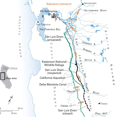
Draining Selenium Tainted Water from San Joaquin Valley
Source: USGS

II.  Selenium and irrigation in California.
The accumulation of selenium (Se) in the waste water draining from irrigated fields in the San Joaquin Valley has become a major problem in California water management, especially as there are only two readily available outlets for the waste water, 1) a  flow into the Sacramento Delta where the waste poisons water destined to be pumped into the California Water Project and then into San Francisco Bay where it threatens wildlife or 2) flow into the interior basin near Hanford where the water evaporates and the resulting brine and dusty soil have truly toxic levels of Se. Selenium and the San Joaquin Valley, a power point presentation from the Geochemistry program at the University of Arkansas, illustrates the sources of selenium and the problems associated with it. There have been a number of proposed solutions to the problem, including a drain into San Francisco Bay (see map above). The problem is far from resolved, and no easy solution is in sight.

Sacramento Delta

III. Salinization of the Sacramento Delta.
Drought caused low water flows and the heavy duty withdrawal of water from the Sacramento River for shipment southward has led to salt water intrusion into the large delta area at the mouth of the Sacramento Rive, the zone where it flows into San Francisco Bay. That salt water intrusion, in turn, threatens the quality of the water drawn into the San Luis Reservoir at the Harvey Banks Pumping Plant near Tracy in San Joaquin County on the edge of the Delta. The State of California has a Bay-Delta Conservation Plan which illustrates the various options currently under consideration to move water from the Sacramento River around the Delta so that it does not pick up salt. Only in California could a water movement proposal this expensive be given serious consideration!
Enhanced by Zemanta

26 October 2010

Urban Water III

Fountain, City of London
©eop

Today's New York Times has a good op ed piece by its regular columnist Bob Herbert concerning the pressing need for investment in urban water supply facilities. While urban uses account for less than 10 per cent of total water use, it is a crucial percentage, supplying the basic needs of millions of US citizens and residents. Saving some or most of the 10-20 per cent of water in urban systems currently lost to leakage would itself justify a large investment in new and renewed facilities, especially in cities where some of the water (and waste removal) infrastructure is over a century old. It would in most circumstances be far cheaper than expanding the supply system to bring in that much more water. Herbert further justifies the investment because it would create jobs and new opportunities for private enterprises. 

Whether the latter points are correct or not, huge investment is going to be essential in the next decade merely to maintain current standards of safety and reliability. Otherwise we are going to see many more events like those that have plagued the Maryland water utilities serving the Washington, DC slurbs. The WSSC in Maryland, in comparison to many urban and slurban water utilities elsewhere, runs a relatively new and up-to-date system. Despite that, it has suffered several major crises over the past couple of years. In those systems which are rapidly aging, it is only a matter of time before a colossal fire in one and in another one an epidemic of water borne disease happens because the water systems are beyond the breaking point, broken and dilapidated. 

25 October 2010

Sudan, the Nile and the Merowe Dam


The nearly always amazing NASA Earth Observatory chose this image of a dam in the desert on its site this morning as its Image of the Day. The accompanying brief article is well worth a read, for it encapsulates the problems of water supply and management in an extremely arid environment with a growing population. It also points to some of the problems of dams in the region and the conflicts over the use of the Nile, crucial for life in both Sudan and downstream Egypt.

20 October 2010

Climate Change and Drought


Source: NCAR
Yesterday 19 October 2010 the Universities Corporation for Atmospheric Research (UCAR) issued a press release describing its work on the water supply aspects of climate change:  Climate change: Drought may threaten much of globe within decades.  The release and the research on which it is based provide yet more evidence, as if such were needed, of how critical climate change is to the human future. No, agriculture cannot simply move from Iowa to northern Manitoba for all to be well! The drying out of middle latitude zones is ominous indeed and does not bode well for maintaining a decent standard of living for the world's increasing human population. The online version of Scientific American has an interesting article based on the UCAR report.
Enhanced by Zemanta

16 October 2010

The Desiccation of the Aral Sea


The Death of the Aral Sea

In the slide set on water footprints we used last session, there was a photo of fishing boats stranded in a desert, at the bottom of what was once a large saline lake, the Aral Sea. Similar to the Great Salt Lake in Utah or the Dead Sea, the Aral sea filled the lowest part of an interior basin with not outlets to the world ocean, but it was far less salty than those two inland seas because it received a much larger annual input of fresh water. Prior to the mid 1970s, it was an important supplier of fish to nearby areas and to the larger Soviet Union. As the lake has dried, the remaining water has become more saline, and many fish species that once flourished have been extinguished, unable to survive in the Aral Sea's remaining and increasingly briny waters.

During the Soviet era there was a huge push to increase crop production in the Central Asian republics, and in particular the production of cotton. The streams flowing from the Hindu Kush mountain range far to the south and east, in particular the exotic rivers the Amy Darya and the Syr Darya, were diverted to irrigate cotton fields.Most of that water has been lost to evapotranspiration, and the rivers now bring virtually no additional fresh water into the Aral Sea. The pictures above show the desiccation of the Sea, almost entirely due to diversion of streams feeding into it. The USGS has a good website describing the desiccation along with some additional photos. 


Enhanced by Zemanta

13 October 2010

The Arid U.S. West

Grand Canyon & Colorado River, 1987 ©eop

After our meeting today, I got questions from several people about books on the arid west of the United States. In class I commented on three titles:

Webb, Walter Prescott. 1931 (original publication, there were several subsequent editions, the most recent appears to be 1983). The Great Plains. (Austin: University of Texas).  Webb was professor of history at the University of Texas and during his lifetime was a greatly influential voice in the study of American history, especially that of the west. He wrote widely on water related topics, particularly as they related to Texas, and his 1954 work More Water for Texas prompted that state to look more carefully at its use of a scarce resource. A 1957 article in Harper's Magazine "American West: Perpetual Mirage" was one of the seminal works in the formation of the environmentalist movement. He has been dead since the 1960s, and his books are a little dated, but they are immensely readable and recommended to anyone with an interest in water and the American West.

Wallace Stegner, who many consider one of the finest American writers, was best known as a novelist, but he also wrote a fine piece of history Beyond the Hundredth Meridian: John Wesley Powell and the Second Opening of the West. It is still in print and also available for Kindle readers. Once again a great read for anyone with an interest in water, American history and the settlement of the west.


John Wesley Powell was a Civil War hero, he lost an arm, and is best known for his epic journey in 1869 through the Grand Canyon. His influence on this country was much greater than that single journey, for he was the effective founder of the profession of geology in the US and of the US Geological Survey (USGS). His Report on the Lands of the Arid Region of the United States published by the USGS has been a touchstone in discussions of the arid regions of the west since it was first published in 1878. He noted that types of agriculture and land management common east of the Mississippi were simply not feasible in the west and made suggestions of possible alternatives. The Report is available in a rather cumbersome form from the American Memory project of the Library of Congress (did not have time to locate other online versions, but I suspect there may be one or more).


There are many, many more good books (not to mention articles) on the arid portions of the U. S. West. A few suggestions:
1. Meinig, Donald. 1968. The Great Columbia Plain. (Seattle: University of Washington Press).
2. Reisner, Marc. 1986. Cadillac Desert. (New York: Viking).
3. Limerick, Patricia Nelson. 2000. Something in the Soil: Legacies and Reckonings in the New West. (New York: W. W. Norton & Company).

11 October 2010

Toxic Spill in Hungary Flows Toward the Danube

Toxic Spill, Ajkai Timföldgyár alumina plant in southern Hungary

At the same time there is good news that the trapped miners in Chile will likely be released from their Hades in a few days, another industrial accident related to mining threatens the water of the Danube in Central Europe. A waste reservoir at a Hungarian People's Republic era alumina plant burst and sent a wall of toxic sludge downstream, the wave from the broken reservoir killing at least four people and injuring many others while making dozens homeless. Several thousand people have been directly impacted by the spill. Some reports suggest that the remaining sludge is also likely to flow into the stream. 

As yet I have not accessed a hydrographic map of the region, so I do not know much about the flow of the small tributary of the Danube, but it appears to enter the Danube upstream from Budapest and possibly also of the city of Györ. Not far away to the south of the spill, but apparently on the opposite side of a divide and in another watershed is Lake Balaton, Hungary's natural treasure. A shallow lake, a plume of toxic materials entering Balaton would be devastating for the economy and the psyche of Hungary. 

A news report on the Scientific American site suggests that the effects on the Danube are likely to be limited, but downstream users of that water, including many in the various Balkan Republics and on to the Black Sea are anxiously watching the spill.  In an earlier posting I discussed the possibility of an oil pipeline bursting and contaminating a major stream in the United States. The aging infrastructure in much of the western world presents many similar risks to rivers and lakes outside of North America.


Area downstream of the Ajkai Timföldgyár alumina plant


Enhanced by Zemanta

10 October 2010

Water and Development in Sub-saharan Africa: a few more notes

Drought in Central Africa 2002-2009

A posting or two back I made some comments about a fantasy of economic development in Sub-Saharan Africa delivered by a speaker from the Mercatus Centre at George Mason University. In her presentation she utterly ignored the immense environmental issues which must be faced if the region is to enjoy even modest rates of economic growth over more than a year or two. Those environmental challenges combine with demographic problems and political instability to make extremely modest projections of future economic expansion for many of the countries in the region little more than wishful thinking. While there are several environmental issues of concern, and all of them are immense impediments to economic growth, at the moment, and likely for the foreseeable future, drought, the absence of adequate water to support rain fed agriculture, is the most significant one.

Drought in central Africa, during the period shown on the map above extending even into normally very humid areas, is the key problem for agriculture on the continent. Raising the currently abysmally low levels of food and fiber output per unit of land (or of labor) requires reliable water sources. In most areas that means adequate rainfall  given the absence of irrigation infrastructure. Recent climatic data, reflecting ongoing climate change, raise substantial doubt that adequate water will be reliably available even in some areas where adequate precipitation was once taken for granted. Shy of huge investments in irrigation facilities farmers will either have to shift to drought resistant crops and new cultivation techniques, usually lowering output per hectare, or face catastrophic decline in output using current crops and techniques.

Drought is also important for burgeoning urban populations. Not a few of those people driven into cities, thereby generating breathtaking rates of urban population growth in some Sub-Saharan countries, have left impoverished agricultural zones where drought has made crop and animal production and therefore subsistence rural living impossible. A number of African cities do not have reliable water supplies adequate even for their present populations, and any population growth means even less water available per capita without large investments to increase urban water supplies. If there is no reliable source of water near a city, then it is nearly impossible to bring adequate quantities of water into it at a feasible investment of resources.

I do not have the time between now and the end of the term further to investigate the dimensions of the problems of drought in Africa, so the topic will be mentioned but not discussed in detail in our course. Anyone who has a serious interest in the continent and its prospects for the future must invest time assessing the impact of drought. That assessment needs to include the immediate term future, for drought in Kenya and adjacent areas has been linked by some observers to the political problems currently brewing there and may also have links to political unrest elsewhere. Anyone who fails to make such an assessment is thoroughly unqualified to consider him or herself an "expert" on Sub-Saharan Africa or its prospects for the future. Hungry people are not easy to govern, and the food scarcity implicit in droughts is hardly conducive to economic growth! 

07 October 2010

The Water Cycle


NASA's Earth Observatory, one of the great treasures of the internet and proof, as if it were needed, that government can do some wonderful things, has just published a web page closely related to our 29 September discussions on the earth's climate and the hydrologic cycle. The Water Cycle discusses climate and the cycling of water and has some excellent illustrations to support the discussion. If ours were an undergraduate class for university credit, I would assign that web page as required reading (viewing?). While ours is not a course for credit, I very strongly urge you to look at The Water Cycle for it reiterates some of what I said and provides some additional information related to our course on world water supply and more importantly, material useful in developing an understanding  of the world's water situation..