Showing posts with label irrigation. Show all posts

27 October 2010

Responses to Questions from class 27 October

Mendoza, Argentina
©eop

Some brief responses to several questions raised in class on 27 October:

I. Dam Licensing. Most dam licensing in the United States is by the Federal Energy Regulatory Commission.

Draining Selenium Tainted Water from San Joaquin Valley
Source: USGS

II.  Selenium and irrigation in California.
The accumulation of selenium (Se) in the waste water draining from irrigated fields in the San Joaquin Valley has become a major problem in California water management, especially as there are only two readily available outlets for the waste water, 1) a  flow into the Sacramento Delta where the waste poisons water destined to be pumped into the California Water Project and then into San Francisco Bay where it threatens wildlife or 2) flow into the interior basin near Hanford where the water evaporates and the resulting brine and dusty soil have truly toxic levels of Se. Selenium and the San Joaquin Valley, a power point presentation from the Geochemistry program at the University of Arkansas, illustrates the sources of selenium and the problems associated with it. There have been a number of proposed solutions to the problem, including a drain into San Francisco Bay (see map above). The problem is far from resolved, and no easy solution is in sight.

Sacramento Delta

III. Salinization of the Sacramento Delta.
Drought caused low water flows and the heavy duty withdrawal of water from the Sacramento River for shipment southward has led to salt water intrusion into the large delta area at the mouth of the Sacramento Rive, the zone where it flows into San Francisco Bay. That salt water intrusion, in turn, threatens the quality of the water drawn into the San Luis Reservoir at the Harvey Banks Pumping Plant near Tracy in San Joaquin County on the edge of the Delta. The State of California has a Bay-Delta Conservation Plan which illustrates the various options currently under consideration to move water from the Sacramento River around the Delta so that it does not pick up salt. Only in California could a water movement proposal this expensive be given serious consideration!
Enhanced by Zemanta

16 October 2010

The Desiccation of the Aral Sea


The Death of the Aral Sea

In the slide set on water footprints we used last session, there was a photo of fishing boats stranded in a desert, at the bottom of what was once a large saline lake, the Aral Sea. Similar to the Great Salt Lake in Utah or the Dead Sea, the Aral sea filled the lowest part of an interior basin with not outlets to the world ocean, but it was far less salty than those two inland seas because it received a much larger annual input of fresh water. Prior to the mid 1970s, it was an important supplier of fish to nearby areas and to the larger Soviet Union. As the lake has dried, the remaining water has become more saline, and many fish species that once flourished have been extinguished, unable to survive in the Aral Sea's remaining and increasingly briny waters.

During the Soviet era there was a huge push to increase crop production in the Central Asian republics, and in particular the production of cotton. The streams flowing from the Hindu Kush mountain range far to the south and east, in particular the exotic rivers the Amy Darya and the Syr Darya, were diverted to irrigate cotton fields.Most of that water has been lost to evapotranspiration, and the rivers now bring virtually no additional fresh water into the Aral Sea. The pictures above show the desiccation of the Sea, almost entirely due to diversion of streams feeding into it. The USGS has a good website describing the desiccation along with some additional photos. 


Enhanced by Zemanta

13 August 2010

Notes VI

Heat Wave in the Indus Valley, June 2007

When I began preparing materials for use with the course on World Water Resources in the autumn, I copied a NASA space photograph of the Indus Valley (not the one above), encompassing Pakistan and large portions of its neighbors India and Afghanistan. Of necessity, India and especially Pakistan will be central topics in the course, but I did not anticipate the catastrophic flooding that has accompanied the summer monsoonal rains of 2010. Control of the waters of the Indus is one of the longest activities of civilization, for the residents of  Mohenjo-Daro and Harrapa, civilizations which flourished almost 5,000 years ago, used the Indus to irrigate their fields and feared its droughts and floods. The current flooding is but one season in an almost constant effort of people to make a livelihood from a beautiful but punishing environment.

Sumer Flooding in the Indus Valley, 3 August 2010


Meanwhile, rains have cooled Moscow somewhat, but peat fires remain a problem. This morning's New York Times has a good piece on peat fires. Along with an explanation of why those fires are so smoky, it also examines how a decision some years ago to drain bogs and mine the peat to use as fuel in electrical generating plants is partially to blame for the smoky fires, dangerous to health, of the extraordinarily hot summer of 2010.

Near the Potomac River, in Loudon County, VA a few kilometers northwest of the Fairfax County boundary, the real estate speculator Donald Trump is redeveloping a golf course. Today's Washington Post reported on the massive tree clearance on that roughly 325 hectare site. The spokesperson for Trump was quoted as saying "The trees threatened the shoreline. Many of the trees, ... stress and eroding (sic) the soil." I guess those trees are like the forest trees claimed by other public relations flacks to create air pollution and acid rain. Loudon County, and its neighbor Fairfax County should encourage widespread cutting of trees, deforestation, in order to protect the environment!

30 July 2010

New Mexico's Acequias: Irrigation and Social Organization

©EOP


Social stability is the last but perhaps the most important of irrigation's "3s", for without adequate social organization and long term stability, irrigation is impossible. In the United States a variety of cooperative, local, state and federal agencies act to provide the necessary social organization for water management, with the Federal Bureau of Reclamation the best known and largest entity. That federal agency has been responsible for the development and maintenance of a series of huge projects in the western United States including the Colorado River projects, the Columbia Basin Project and parts of California's complicated water management system. All of those systems have venerable ancestries. Immense irrigation projects under centralized control were known to the ancient societies of Mesopotamia, while small and locally controlled irrigation projects date to long before the beginnings of recorded history in all arid and semi-arid parts of the world where agriculture has been practiced.

The state of New Mexico, one of the longest European settled parts of the United States, has a tradition of irrigated agriculture stretching back well before the first European contact. With parts of the Colorado River projects and large ones along the Rio Grande (Rio Bravo del Norte) New Mexico is something of a microcosm of virtually all of the types of irrigation water control known in the western United States. It also has some of the more complicated water laws, for it is a mostly arid state but also has high mountains where melting winter snows are the sources of exotic rivers, most notably the Rio Grande and its largest tributary the Pecos. Allocation of that water is a complicated task, a task made increasingly difficult by drought years when mountain show is scarce. In addition to dividing water between users who live within its boundaries, New Mexico is obligated to send water to downstream users on the Rio Grande, the Pecos and several smaller streams into Texas and Mexico (and in a less complicated set of relations to downstream users on the Colorado - New Mexican users of water destined for the Colorado are few in number).

Snow in New Mexico, 16 March 2005


Acequias in New Mexico (with a few also in Colorado) are numerous, almost 1,000 of the gravity driven channels bring water from highland areas for use in towns and agricultural plots. They are also very old, brought to the area by settlers from Mexico and Spain who were familiar with community operated irrigation first in Spain and later in New Spain (Mexico). Some of the canals themselves may actually date to pre-contact groups, for acequias use an ancient technology widespread where snowmelt in nearby mountains allows agriculture on downhill sites. The social organization in pre-contact groups is for the most part unknown, and some of the current aspects of acequia management may have roots there, but the acequia associations are quite similar in character to much older ones in México and in Spain.


While ancien regime Spain and its colonies were not in the remotest sense of the term democratic in almost all aspects of governance, acequia associations were participatory democracy in its most pristine form. Yearly or more often those who had a share in the water delivered by an acequia met, a mayordomo (ditch boss) or leader was chosen, and both the allocation of water and of tasks necessary to keep the channels open, free of silt and debris, were made by common consent. A kind of corvée was in effect, for peasants were compelled to spend time working on the channels, but instead of working for benefit of the state or the nobility as in other corvée, they were working for the common good of their local community and for personal benefit.

The acequia associations of contemporary New Mexico share that characteristic of participatory democracy (no, New England town meetings are not the only example of direct democracy in the United States). For the past several decades the associations have become legal entities and an integral element in the management of water in New Mexico. Beneficiaries of the water are compelled to participate in the maintenance of the ditches, and in years of drought they must make the difficult decisions on how to allocate the scarce resource.

Folr a fascinating look at acequias and the experience of being a ditch boss in New Mexico, see Stanley Crawford's Mayordomo: Chronicle of an Acequia in Northern New Mexico.
Enhanced by Zemanta

24 July 2010

Irrigation and Salt

Wind eroded and salt encrusted hoodoos, Atacama Desert, Chile
©EOP

For the past several days I have been wracking my memory and rifling my notes to find the first time I encountered the "3 s" of irrigation - silt, salt and [political] stability. The idea is so straightforward that perhaps the term has been around forever, or at least as long as supplemental water has been used to grow crops. Salt and silt threaten the utility of irrigation works and the soils to which water is applied, while political stability is required if irrigation works are to be maintained over time. Irrigation at any significant scale is a cooperative activity requiring many people to participate in the construction and upkeep of the impoundments to store water, the canals to bring it to fields, and the drains to remove excess water and prevent water-logging of soils. Archaeology and history provide numerous examples of cases where irrigation systems fell into disrepair because soils became too saline for use, because impoundments and canals were clogged with silt, or because political unrest made it impossible to maintain the irrigation works. On occasion the destruction of irrigation works has been a deliberate ploy in warfare as an enemy attempts to starve a population by destroying its agriculture.

Silting behind large dams was noted in the posting on immense dams. It is also a problem behind even the smallest hydraulic barriers and unless water is moving rapidly, it can be a problem in canals as well. In a later posting we shall examine that idea in a bit more detail. In later postings and in the lectures we shall also examine the importance of political stability in the maintenance of irrigation systems.

Today I would like to make a few comments about salt as an enemy of irrigation projects. Salinization is a complex problem for all water systems. Many mineral salts, including the most important single one NaCl or sodium chloride (common table salt), dissolve readily in water. At low concentrations those salts can be be inconsequential or even beneficial for human consumption and agricultural use. At some level of concentration, however, they become a problem, and beyond some maximum concentration the water is no longer useful. We may look at salts other than NaCl later, but for today let us limit discussion to it.

Crop plants vary greatly in tolerance to saline soils and salty water. Grains and grasses tend to be more tolerant than other field crops, while most tree crops are intolerant of saline conditions. When land is being considered for irrigation, an early test is of the natural salinity of the soil recognizing that high value fruit, vegetable, fiber and tree crops are unlikely to thrive if the soil is already quite saline. Grain crops in general do not return enough value per hectare to justify investment in irrigation facilities.

Salts accumulate in soils through a variety of processes, and some soils are naturally saline, especially ones derived from rock substrates containing high levels of salt. Elsewhere in arid areas evaporation of surface ponds and lakes leads to pockets of salty soil (often called playas in Mexico and the southwestern US  and salinas in South America). Once overlain by glaciers, with numerous small ponds and lakes left as the glaciers receded the now semi-arid southern part of the Canadian province of Alberta, its agricultural area, has salty soils spread quite widely. Some of those soils derive from salty substrates, while other areas were once covered by waters now evaporated away. As grains and grass fed livestock are the primary agricultural products, the presence of salty soil is not a great hindrance to agriculture in Alberta (uncolored areas on the map are generally unsuitable for agriculture for other reasons, while blue areas are lakes and streams).

Source: Agriculture Canada and Province of Alberta

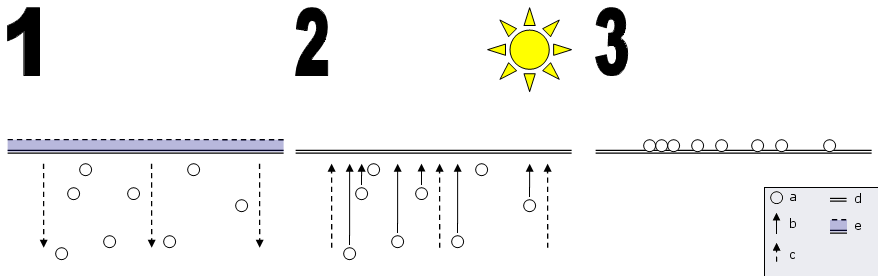
Commonly soils become salty after irrigation commences. Not infrequently in arid areas the water used for irrigation is itself  saline. Rainwater dissolves salt as it flows across desert landscapes in infrequent storms. Water captured in impoundments becomes increasingly saline as evaporation occurs. The extremely high rate of evaporation in hot desert areas like those of the southwestern US mean that water leaving Lake Powell or Lake Mead is far saltier than water flowing into those reservoirs. Applied to the soil in areas with high rates of evaporation, some salt from that water is added to the soil with irrigation. Much of the salt is leached to lower levels in the soil profile, and some of that, in turn, is washed away. But water retained in the soil can be  returned to the surface in a capillary process as water is drawn upwards to the soil surface by evaporation.

Rain or irrigation, in the absence of leaching, can bring salts to the surface by capillary action
Source: Wikipedia Media Commons

Only if it is possible to flush the salts by using a large quantity of water to redissolve the salts and thus to remove them can the eventual salinization of the soils be prevented. Accumulation of salt in soils has rendered substantial areas once productive agricultural zones into salty desert too saline for crops. In the Middle East and in arid parts of Asia, many square kilometers of once productive agricultural activity have been abandoned because of salinization. 

Source: Australia Department of Agriculture, Fisheries and Forestry, Bureau of Rural Sciences

While irrigation agriculture is fairly new to Australia, the Murray River Basin in the southeastern quadrant has been irrigated for more than a century. Not surprisingly, that arid area is reporting salinity problems as the map illustrates.

18 July 2010

Water and Agriculture: A General Overview

Boh Tea Plantation, Cameron Highlands, Malaysia
©EOP

Agriculture is by a considerable measure the largest single human use of water. Leaving animal husbandry aside for the moment, some of the water used by crop plants is taken up directly from soil moisture created by precipitation in what is often called rain fed agriculture. It has become conventional to call that water from precipitation green water (a somewhat unfortunate usage, for the term is also applied to water seriously contaminated with algae)In the humid zone countries of the northern Hemisphere, including the eastern parts of the United States, green water allows a variety of crops to be grown without supplemental irrigation, and precipitation supplies all of the water for the crop plants. Such is the case in the tea growing area in the tropical highlands of Malaysia where tea is but one of a variety of crops grown dependent on the ample rainfall.

Elsewhere agriculture as presently practiced requires the addition of water beyond that provided by precipitation. Water obtained from streams, lakes and underground aquifers is usually termed blue water (again an unfortunate usage, for blue water has a quite different meaning to sailors). In sub-humid zones  irrigation may provide only small amounts of additional water applied at specific times during the growing season. In truly arid areas little or no crop production is possible without continual irrigation throughout the growing season. An area like the Salt River Valley of Arizona would not be useful for agriculture if not for irrigation.  Many other areas in the western United States can be used for water dependent crops only because of irrigation. Without irrigation in those areas, rain-fed agriculture could only produce grains Like wheat and barley.

The map below illustrates blue water withdrawals from various sources like lakes and reservoirs and underground aquifers for agriculture. It illustrates the great importance of supplemental water in tropical and subtropical areas, particularly in the Middle East and Asia. A very large fraction of the world's population depends on food grown with at least some use of blue water in irrigation, including most of the populations of India and China. The data are averages for usage in whole countries from the Food and Agriculture Organization (FAO), a Rome based unit of the United Nations.


Not all water used in agriculture is consumed, that is lost to evapo-transpiration or incorporated in the crop, but a great deal is. The map below composed from remote sensing imagery at the Institut für Physische Geographie (Physical Geographical Institute) of the Johann Wolfgang Goethe University of Frankfurt am Main in Germany shows the consumptive use of blue water by agriculture across the globe. The map is part of a very large project on world irrigation at the institute. 


01 June 2010

Columbia Basin Project I

Grand Coulée Dam, 2005, © EOP


The Tennessee Valley Authority (TVA) is perhaps the most famous water project in the United States, but during the Depression years and the New Deal of the 1930s, several huge water projects were initiated or expanded under the control of the Bureau of Reclamation. As today is my birthday, I thought I might indulge myself and write a little about the one I know the best and with which my family has had close connections, the Columbia Basin Project an irrigation and hydroelectric scheme using the huge flow of the Columbia River, an exotic river flowing across the northern and central parts of Washington State. Its centerpiece is Grand Coulée Dam (shown above and again at the end of this posting) for many years the largest hydroelectric facility on earth and still the largest in the United States.

In the rain shadow of the Cascade Mountains, the Great Columbia Plain (pace Donald Meinig) was a vast steppe or high desert atop one of the more geologically interesting bits of the United States, the Columbia basalt flow. In the early years of settlement, after the Northern Pacific Crossed that steppe at a diagonal with its route from Spokane to Pasco, there was some settlement and dryland agriculture, wheat farming and ranching, but the area was lightly populated. Only water was necessary for an agricultural bonanza, it was claimed. The Columbia Basin Project, long a goal of Chambers of Commerce and other civic booster groups in the central and eastern part of Washington State, was intended to provide that water in a scheme similar, though not identical, to the TVA, with the dual goals of long term regional development and stimulus spending in a depression.

A make-work project to employ some of the large number of unemployed, Grand Coulée Dam was begun in 1933 and completed 9 years later, one of the largest engineering projects ever undertaken up to that time, though in publicity it was somewhat overshadowed by construction of Boulder Dam in a dramatic canyon of the Colorado River ongoing at the same time. When it was being built there was no clear idea of how or where the vast amount of electricity Grand Coulée Dam could produce would be consumed, though sale of electricity was to help fund the project and pay for the more than 1000 km of irrigation canals and drainage ditches the project would require if carried to completion. World War II defense industries, including Boeing's Seattle plants, rendered the issue of where to sell the electricity moot until 1945, after which a series of aluminum smelters purchased much of the electricity produced.

Meanwhile the irrigation scheme was constructed, albeit at a slower pace. Several of the major canals and drainage works were not completed until the 1960s and 1970s. Irrigation has transformed the sere steppe into an immense green expanse, at least in Spring and early summer. Areas where the distance between trees was measured in kilometers in the 1930s or even as late as the 1960s, have become orchards and vinyards. Dryland wheat or barley has been replaced by water intensive field crops including corn (maize). Sounds wonderful, the bonanza promised by early boosters, but the change has come at some environmental costs to be examined in a later posting.

Grand Coulée Dam, 2005, © EOP